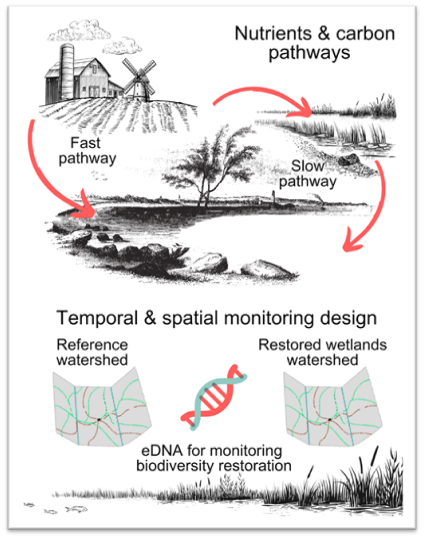
Water is the source of all life and is under serious threat.¹ Human activities such as intensive farming, wastewater production, fossil fuel emissions, and deforestation have disrupted the balance of nutrients between land and water.² An estimated 3.4 million km² of global inland wetlands have been lost since 1700, primarily for conversion to croplands, exacerbating this problem.³ Wetlands create a ‘slow pathway’ for water flow crucial for retaining nutrients and sediment trapping, nutrient removal and chemical detoxification.4
In places where wetlands are absent, a ‘fast pathway’ is created, resulting in nutrients flowing swiftly into streams and larger bodies of water like rivers, lakes, and oceans.4 This fast pathway can sometimes result in massive algae blooms and dead zones where aquatic life cannot survive, potentially reducing biodiversity.4
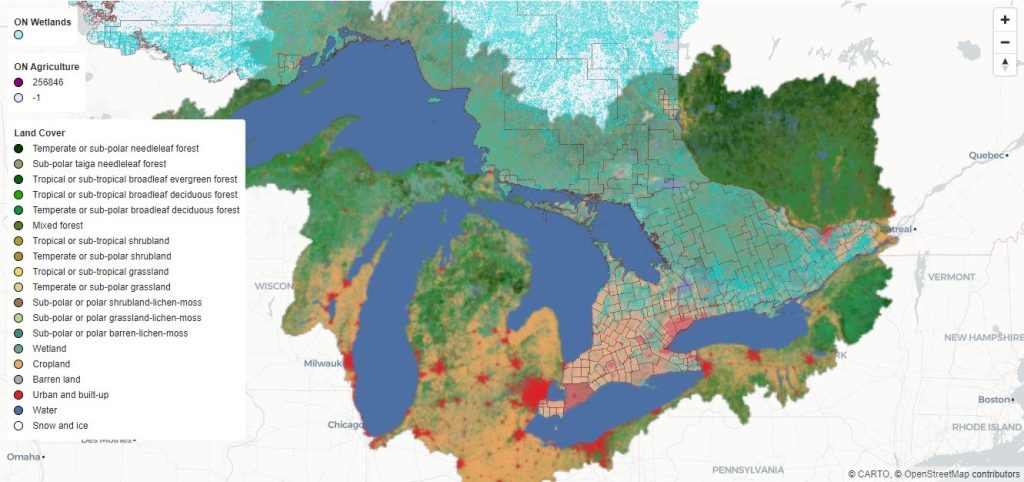
Fast pathway challenges are evident in Lake Erie. Half of Canada’s prime agricultural lands sit on the north shores of Lake Erie and across to Lake Ontario.4 Most of the region surrounding Lake Erie has been intensely urbanized or utilized as agricultural land.4 Consequently, there is potential for nutrient runoff from crop fields to affect the ecosystem and the livelihoods and well-being of surrounding communities.5
The Project
Nature Analytics is collaborating with researchers from the University of Guelph to collectively support wetland restoration. Through science-informed decisions, this collaboration aims to enhance ‘slow pathway’ water movement across landscapes to increase nutrient retention, carbon storage, and biodiversity. Moving forward, we anticipate that biodiversity monitoring will play a more central role in design and citing of wetland restoration projects.
Our Role
Future Directions
By enhancing data analysis capabilities and providing accessible tools for environmental monitoring and decision support, Nature Analytics aims to contribute significantly to the design and evaluation of conservation and restoration efforts in the Lake Erie basin. This initial foray into developing a GIS-driven dashboard could serve as a platform for further developing a wetland restoration siting tool to improve watershed health, restore biodiversity, and promote sustainable practices.
Collaborators
B. Harford, S. Astbury
References
- United Nations Environment Programme. (2023). Rivers, lakes under mounting pressure. UNEP. https://www.unep.org/news-and-stories/story/rivers-lakes-under-mounting-pressure
- Un-Water. (2024). Water Scarcity | UN-Water. UN-Water. https://www.unwater.org/water-facts/water-scarcity
- Fluet-Chouinard, E., Stocker, B. D., Zhang, Z., Malhotra, A., Melton, J. R., Poulter, B., Kaplan, J. O., Goldewijk, K. K., Siebert, S., Minayeva, T., Hugelius, G., Joosten, H., Barthelmes, A., Prigent, C., Aires, F., Hoyt, A. M., Davidson, N., Finlayson, C. M., Lehner, B., . . . McIntyre, P. B. (2023). Extensive global wetland loss over the past three centuries. Nature, 614(7947), 281–286. https://doi.org/10.1038/s41586-022-05572-6
- Small wetlands can have big impacts | American Society of Agronomy. (2022). https://www.agronomy.org/news/science-news/small-wetlands-can-have-big-impacts/
- Great Lakes Guide. (2023). Lake Erie | Great Lakes Guide. https://greatlakes.guide/watersheds/erie